Collections Online
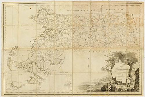
Map of Massachusetts Proper. Compiled from Actual Surveys made by Order of the General Court and under the inspection of Agents of their appointment.
To order an image, navigate to the full
display and click "request this image"
on the blue toolbar.
-
Choose an alternate description of this item written for these projects:
- Witness to America's Past
This map, published in 1802, is the second edition of the first official map of Massachusetts entitied, Map of Massachusetts Proper, originally published in 1801. The idea for a state map began to take shape in 1791 when Osgood Carleton, one of the first professional mapmakers in America, suggested a regional map of Southern New England based on town surveys. The Massachusetts Historical Society supported the idea and helped persuade the Massachusetts General Court (the state legislature) to pass a state mapping law in 1794. Osgood Carleton produced the original design of the state map using information gathered from town surveys and information supplied by the Historical Society.
After Carleton completed his map, a state committee, including members of the Massachusetts Historical Society, examined the engraved plates and judged them to be unsatisfactory. Working from Carleton's design and the information he gathered, the official map was re-engraved by Samuel Hill and Joseph Callender and published by the Commonwealth of Massachusetts in 1801. The first edition of the map was for the use of the state and the towns; a second edition (1802), for the use of court officials, legislators, and schools. For its efforts, the Historical Society was to benefit from a share in the copyright of the map, but there is no evidence that it ever profited from this arrangement.
Sources for Further Reading
Witness to America's Past: Two Centuries of Collecting by the Massachusetts Historical Society. Boston: Massachusetts Historical Society and Museum of Fine Arts, Boston, 1991.

